


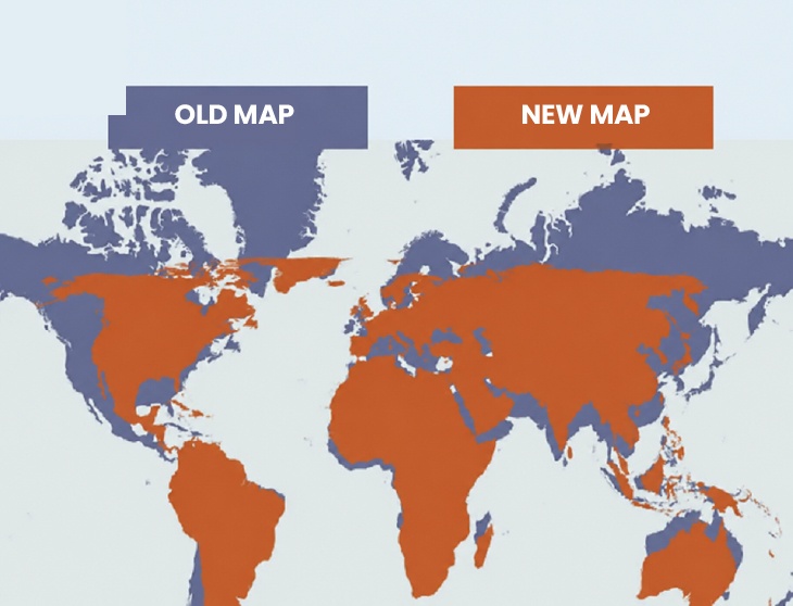
Open any standard world map and India appears as a modest wedge tucked below China — respectable in size, but nowhere near as commanding as the country’s actual landmass would suggest. That’s not a coincidence. This isn’t some minor detail — it’s a nearly 450-year-old flaw in how we’ve all been taught to see the planet, and the UN is now pushing for a fix.
Blame Gerardus Mercator. Back in 1569, this Flemish cartographer wasn’t trying to represent the world accurately — he was solving a navigation problem. Sailors needed a way to plot compass courses as straight lines, and Mercator’s projection made that possible. The catch? Landmasses got progressively stretched out the farther they sat from the equator, inflating everything toward the poles. The result is a map that flatters countries at high latitudes — Russia, Canada, most of Europe — while shrinking everything closer to the equator, India included.
India sits close enough to the equator that it takes a real hit under this system. Next to Russia or Canada on a Mercator map, India looks like a fraction of their size. The actual difference is far less extreme than the map suggests. Africa’s case is the starkest example — on a Mercator map, it looks barely bigger than Greenland, when in fact it dwarfs it, coming in at nearly 14 times the size.
Enter Equal Earth, the UN-endorsed fix built in 2018 by a group of cartographers who threw navigational accuracy out the window entirely. Their priority was different: get the relative sizes right, even if sailors can no longer use it to chart a course. Under this projection, India visibly gains ground, filling out closer to its real proportions, while traditionally “oversized” countries near the poles shrink down to size.
This isn’t purely academic. As Kenyan geographer Kioko Muendo has pointed out, maps quietly shape how people perceive a country’s political and economic weight — and for a nation like India, being visually undersized on the world’s default map has meant looking smaller than its billion-plus population and growing global influence would imply.
Equal Earth isn’t without trade-offs of its own — it gives up Mercator’s navigational accuracy and doesn’t preserve exact distances between points. But no map projection can get everything right simultaneously. For India, though, the switch means finally being seen — literally — closer to its true scale on the world stage. isn’t without trade-offs of its own — it gives up Mercator’s navigational accuracy and doesn’t preserve exact distances between points. But no map projection can get everything right simultaneously. For India, though, the switch means finally being seen — literally — closer to its true scale on the world stage.