


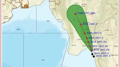
The India Meteorological Department (IMD) has said that another deep depression developed over the north Andaman Sea and the surrounding coast of Myanmar four days after Cyclone Arnab turned out to be just a low pressure system without strengthening into a cyclonic storm.
In an update on Monday, September 28, the IMD said the depression had intensified into a deep depression. The system was located on the same area around 1130 am IST over latitude 16.4N and longitude 97.3E.
The weather system was located around 40 km west-southwest of Mawlamyine, 130 km east-southeast of Yangon and 130 km southeast of Bago in Myanmar. It was also located about 490 km to the east-northeast of Coco Island and 610 km to the northeast of Mayabunder in the Andaman Islands.
The IMD states that the system is likely to make the continental landfall between the Myanmar coastline and Yangon and Kyaikto during late evening/night of 28 September with very high chances. The marine bulletin issued by the IMD earlier predicted that this system may get deep depression further away from the Myanmar coast.
It is forecast to turn north-northwestward and pass over coastal Myanmar over next two days, followed by coastal east-central and northeast Bay of Bengal and towards Southeast region of Bangladesh during the next two days.
Weather is also likely to generate rain and thunderstorms over some areas of the region. Myanmar’s meteorological department has issued a warning for heavy rain in some places and extensive rainfall throughout the country as the system heads into the country.
As for the Andaman and Nicobar Islands, the IMD sent out warnings of heavy rainfall on September 28, as well as for thunderstorms on the days ahead.
The new system has emerged just after Cyclone Arnab failed to intensify properly into a full-fledged cyclonic storm.